Tectonic Activity of the World
By Andrew Alden, About.com Guide

(Image courtesy NASA)
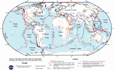
This schematic map (click it to see it at full size) summarizes a great deal of information related to plate tectonics: areas of oceanic and continental crust, major faults and fault zones, active volcanic centers, names and boundaries of major tectonic plates, spreading centers with their spreading rates, and transform zones. In addition, it shows other activity that may or may not be related to plate tectonics. The volcanoes of the Hawaiian Islands, for instance, make up a hotspot, and we don't have a final explanation for them. The scattered volcanoes in northern Africa are also a puzzle, but they are active and belong here too.
This is a snapshot of where we know tectonic activity is occurring now, that is, within the last million years. Notice that everything labeled on this map is a geologic entity, not a geographic one. No countries, no rivers, no mountain ranges, not even the oceans and continents are named on it. It is like an alternative, secret world. When experts get together to discuss plate tectonics, they are all familiar with this detail without having to look it up. But in fact, almost anywhere on the globe would have a much more complex map if you zoomed in on it.
للحصول علي الصورة بحجمها الطبيعي يرجي الرجوع إلي الرابط المشار إليه في المصدر


ساحة النقاش