Geography of the Ocean and the Structure of Planet Water
Geography of the Ocean and the Structure of Planet Water
The Global Ocean
The five oceans from smallest to largest are: the Arctic, Southern, Indian, Atlantic and Pacific.

These five oceans are connected and are actually one huge body of water, called the global ocean or just the ocean. If you were to add the smaller seas like the Barents, Beaufort, Chukchi, Kara, Laptev, East Siberian, Lincoln, Wandel, Greenland and Norwegian, etc. you would have a total area of the ocean of about 361,000,000
Our hydrosphere (ocean plus all freshwater in ground water, lakes, rivers, snow, ice and the atmosphere) makes up about 0.023% of the total mass of the Earth.
 The word “Ocean” comes from Okeanos
Terrigenous
Consequently, terrigenous deposits are confined to narrow marginal bands close to land like continental shelves and are deepest near the mouths of large rivers or desert coasts. Pelagic deposits derived from seawater are red clays and the skeletal remains of organisms that have died and sunk to the ocean floor.
These include pelagic red clays
The Arctic Ocean
The Arctic Ocean is divided by an underwater ocean ridge called the Lomonosov ridge
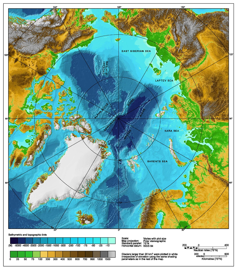 varies consisting of fault-block ridges
 Ice used to cover most of the Arctic Ocean year round (this is now changing drastically due to global warming). When the ice melts, salinity and subfreezing temperatures vary. The subfreezing temperatures cool the air traveling towards the equator, mixing with warmer air at middle latitudes, resulting in rain and snow. Marine life is thought to be relatively scarce in the cold waters of the Arctic Ocean except in the open, southerly waters.
Air traffic is common over the Arctic because it is the shortest route between the Pacific coast of North America and Europe. For boats, major ports are the Russian cities known as Murmansk and Arkhangelsk (Archangel).

The Southern Ocean The Southern Ocean is the world's fourth-largest body of water. It encircles Antarctica and is actually divided among the Atlantic, Indian, and Pacific Oceans. Most people of North America and Continental Europe have no name for the area and regard the area as parts of the Atlantic, Pacific, and Indian Oceans simply extending to Antarctica. However, because mariners have long referred to this area as the “Southern Ocean” it was accepted as an ocean in 2000 by the International Hydrographic Organization
This ocean is predominantly deep water, averaging 4,000-5,000
Current Environmental IssuesAn increase in solar ultraviolet radiation originating from the Antarctic ozone hole
International Environmental AgreementsMost recently designated as its own ocean, the Southern Ocean is required to follow all international agreements regarding the world's oceans. The boundaries between the oceans are set by the International Hydrographic Organization
The Indian Ocean
when the Red Sea and the Persian Gulf are included. The volume of this massive body of water has been estimated at 292,131,000 km³ (or 70,086,000 mi³). Other features include small islands around the continental rims such as Madagascar (the world's fourth largest island), Comoros, Seychelles, Maldives, Mauritius, Sri Lanka, and Indonesia.
The Indian Ocean is an important transit route between Asia and Africa, a geographical feature that has fueled some strong historical conflicts. Because the Indian Ocean is so enormous, no nation had ruled it until the beginning of the 1800s when Britain was able to dominate much of the surrounding land.
Underneath the surface of the Indian Ocean lies the convergence of the African, Indian and Antarctic crustal plates- their junctures marked by the Y-shaped branches of the Mid-Oceanic Ridge and a stem running south from the edge of the continental shelf near Mumbai, India. The resulting ridges subdivide the eastern, western and southern basins into smaller basins. The Indian Ocean consists of narrow 200 km (125 mile) continental shelves with the exception of a shelf of width that exceeds 1,000 km (600 miles) off of Australia's western coast. On average, the depth of this ocean is 3,890
Large rivers flowing into the Indian Ocean include the Zambezi, Arvandrud/Shatt-al-Arab, Indus, Ganges, Brahmaputra and the Irrawaddy. Monsoons control the currents in this oceanographic region. One current flows clockwise in the northern hemisphere and the other flows counterclockwise south of the equator. These two large, circular currents make up most of the flow pattern. When the winter monsoon occurs, the currents in the north are reversed.
The circulation of deep water is mostly controlled by water flowing in from the Atlantic Ocean, the Red Sea, and Antarctic currents. The surface temperature is 22°C (72°F) north of 20° S latitude and exceeds 28°C (82°F) to the east. Surface temperatures drop quickly south of 40° south latitude. The highest salinity
The Atlantic Ocean
The Earth's second-largest ocean is the Atlantic, a name derived from the “Sea of Atlas” in Greek mythology. It covers approximately one-fifth of the entire global ocean. Water drains into the Atlantic from a land area four times the size of both the Pacific and Indian oceans. The area of the Atlantic excluding the seas next to it is 82,400,000 km² and the volume is 323,617,637 km³. Including the adjacent seas the area is 106,400,000 km², and the volume is 354,700,000 km³. Including the adjacent seas, the Atlantic averages 3,332 m (10,932 ft) deep. Excluding the neighboring seas the Atlantic has an average depth of 3,926 m (12,881 ft). The deepest area is found in the Puerto Rico Trench
The geography of this ocean can be visualized by imagining a large S-shape basin extending north to south and divided into North Atlantic and South Atlantic by counter currents at the equator (about 8° N latitude). In the west, the Atlantic stretches all the way to North and South America. In the east, the Atlantic is connected to the Pacific Ocean by the Arctic Ocean in the north and the south. Incredible human labor created the Panama Canal, which now connects the Atlantic and the Pacific Oceans. The 20° east meridian divides the Atlantic from the Indian Ocean in the east. The Arctic Ocean is separated from the Atlantic by a line from Greenland to southernmost Svalbard to northern Norway. The lowest point of the Atlantic is 4,665
The coasts of the Atlantic are marked by scores of bays, gulfs, and seas, including the Caribbean Sea, the Gulf of Mexico, Gulf of St. Lawrence, Mediterranean Sea, Black Sea, North Sea, Baltic Sea and the Norwegian-Greenland Sea. Islands include Svalbard, Greenland, Iceland, Rockall, Great Britain, Ireland, Fernando de Noronha, the Azores, the Madeira Islands, the Canaries, the Cape Verde Islands, Newfoundland, Bermuda, the West Indies, Ascension, St. Helena, Tristan da Cunha, the Falkland Islands and South Georgia Island.A giant submarine mountain range called the Mid-Atlantic Ridge extends from Iceland in the north to about 58° S latitude, becoming very wide at approximately 1,600
The deep ocean floor is mostly flat but there are quite a few seamounts, guyots and deeps or trenches. The deepest trench in the North Atlantic is the Puerto Rico Trench at 8,605
The Pacific Ocean
The Pacific is the world's largest body of water and was named by the Portuguese explorer Ferdinand Magellan who found the Pacific very peaceful (“pacifique”, means peaceful in French) for most of his journey from the Straits of Magellan to the Philippines. In contrast to its name, the islands of the “peaceful ocean” are often slammed by typhoons and hurricanes. The countries that border the Pacific, or the Pacific Rim, often experience volcanoes and earthquakes. Entire towns have been wiped out by Tsunamis, the large waves caused by an underwater earthquake.The Pacific Ocean covers a third of the Earth's surface, has an area of 179.7 million km² and extends about 15,500

Most of these islands are located south of the equator. The largest seas of the Pacific include: the Celebes Sea, Coral Sea, East China Sea, Sea of Japan, South China Sea, Sulu Sea, Tasman Sea, and Yellow Sea. The Pacific and Indian Oceans are connected by the Straits of Malacca in the west while the Pacific and Atlantic Ocean are connected by the Straits of Magellan in the east.
Most of the ocean floor in the central Pacific basin is fairly level and has a mean depth of 4,270
»Wikipedia: Earth منقول للامانة good luck Mohamed hassaan


ساحة النقاش